 Note: This is the first in a series of posts based on the photos I took today at the Ohio State Fair.
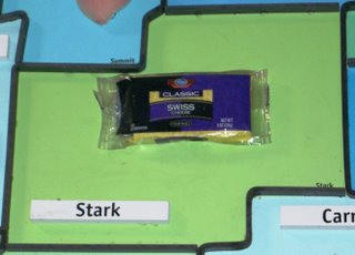
The first thing you see when you walk in to the "Nationwide Ag. and Hort. Building" is this map of Ohio.
It drew my attention because I saw something very similar in my parent's attic the last time I was home. MY map represented Ohio's Native American burial sites in salt dough. It was, if I remember correctly, created for my seventh-grade Ohio Studies class.
The map at the fair was much larger than the one I created and, given that it was not made from salt dough, I assume much less prone to cracking on the long bus ride to junior high.
Also, the fair map represented the primary agricultural product of each of Ohio's 88 counties instead of indian burial grounds.
For example, there are two plastic pigs pasted inside the outline of Coshocton. Putnam has Potatoes, Mahoning has Sunflowers and Franklin has a picture of a Golf Course. (after reviewing the map’s key, I discovered that Franklin County is a big producer of sod)
I found this map quite interesting and informative and spent at least ten minutes reviewing all of the crap pasted to the big piece of cardboard. To my suprise, everyone else walked right by...
Anyway- just as I was about to walk away to get a closer look at the REALLY large tractor outside, I noticed something extremely funny stapled to Stark County: a plastic-wrapped block of Kroger swiss cheese.

If you don’t find this funny- please read my previous post about Blackwell’s swiss cheese comment.
Or, check out the video.


0 Comments:
Post a Comment
<< Home